Maps & Science
What is Habitat Suitability Modeling?
Habitat suitability modeling is a statistical method for identifying the environmental factors that a species selects for, or avoids, based on the availability of those factors across a landscape and outputs an index of suitability based on these factors. Using a geographic information system (GIS), these index values can be mapped and analyzed to portray areas of potential habitat for the species. It is important to note that modeling results do not show the actual occurrence of the species.
How does the Conservation Credit System use Habitat Suitability Modeling?
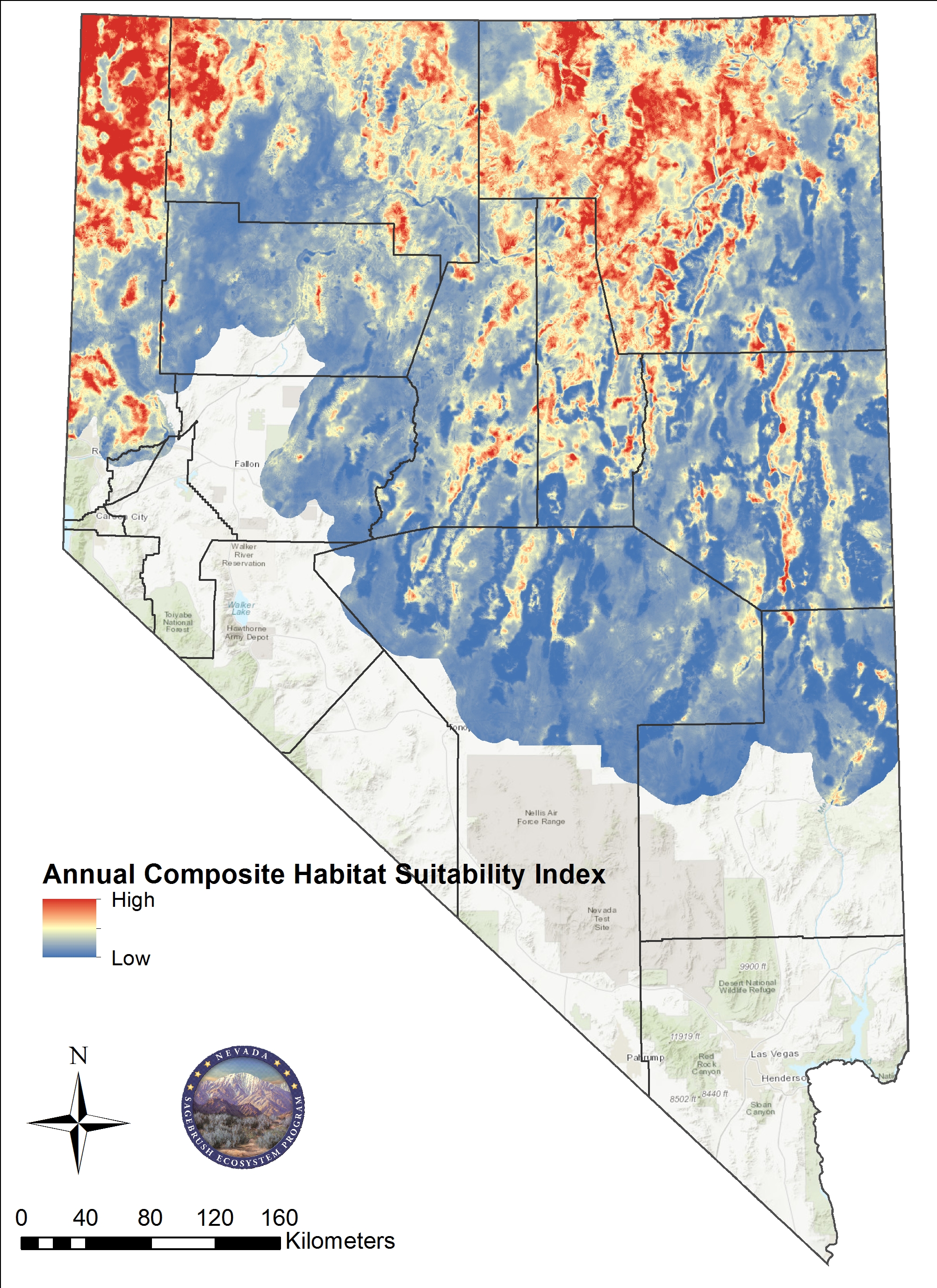
The State of Nevada worked with the U.S. Geological Survey to develop a habitat suitability model for Greater Sage-grouse (GRSG) in Nevada. The model used GRSG telemetry data and extensive environmental data (e.g., vegetation communities, elevation, and human activity factors) as inputs to predict suitability. The results of the habitat suitability model were then used to build seasonal habitat suitability index (HSI) maps, which were used in the CCS Habitat Quantification Tools.
The GRSG habitat management category map was developed from habitat suitability modeling efforts and the resulting HSI maps to represent habitat areas at the landscape scale and the importance. The Sagebrush Ecosystem Council formally adopted the updated and revised Nevada Management Categories map April 2025. This revision included updated habitat selection modeling by the USGS, updated lek information in the space use modeling component, the addition of a major road and urban area mask, and a reduction to the extent of the management categories to the Biologically Significant Units. In addition, the state has updated terminology to Priority Habitat Management Areas (PHMA), General Habitat Management Areas (GHMA), and Other Habitat Management Area (OHMA) to align with Federal Land Use Plans. This map is used in the CCS, for management of GRSG in Nevada at the state and federal level, and to support conservation planning decisions.
Spatial Data
Geospatial files for seasonal/composite habitat suitability and GRSG management categories in Nevada and northeastern California have been developed by the USGS and the Nevada Sagebrush Ecosystem Program (Milligan et al. 2024). Included is a layer file to symbolize the data following the State's format. Please review the metadata as it describes the methods for developing this layer and use the Milligan et al. 2024 citation that is listed in the metadata when referencing the data.
USGS Open File Report
This peer-reviewed report presents the process for developing spatially explicit maps describing relative habitat suitability for GRSG in Nevada and northeastern California. Maps depicting habitat suitability indices (HSI) values were generated based on model-averaged resource selection functions informed by more than 22,000 independent telemetry locations from more than 2,000 radio-marked GRSG across 15 project areas in Nevada and northeastern California collected during a 12-year period (2009–2021).
Maps
The Sagebrush Ecosystem Program works with the U.S. Geological Survey to develop mapped suitable habitats for GRSG using habitat suitability modelling techniques. This data is used to best represent GRSG habitat areas at the landscape scale and delineate them according to importance.
The CCS Habitat Management Categories map is a result of the modeled habitat divided into four categories of importance. This map is used to determine projects eligibility for the CCS and is incorporated into the credit and debit calculations for projects.
- PHMA+: High GRSG Selection and High Survival with High GRSG Abundance and Space Use (only used for siting importance in restoration)
- PHMA: High, Moderate, or Low GRSG Suitability with High GRSG Abundance and Space Use
- GHMA: High GRSG Suitability with Low GRSG Abundance and Space Use
- OHMA: Moderate GRSG Suitability with Low GRSG Abundance and Space Use, possibly unmapped habitat or connectivity corridors for genetic diversity.
The HSI map is a compositional map of multiple suitability indices and is most often used for credit and restoration project development.
Please contact SETT for more information or more detailed shapefiles.
CCS Projects Interactive Mapping Tool
A map of locations and details on CCS Credit and Debit Projects is located below. This tool is meant not only to provide the public information, but also to better accommodate sale or purchase of credits in the CCS. While projects are identified in each of these tools, contact information for credit and debit project proponents is available from the SETT on request.
CCS Projects Interactive Mapping ToolCCS Site Screening Tool
Potential credit developers can quickly get an idea of their property’s suitability for participating in the CCS.
CCS Site Screening Tool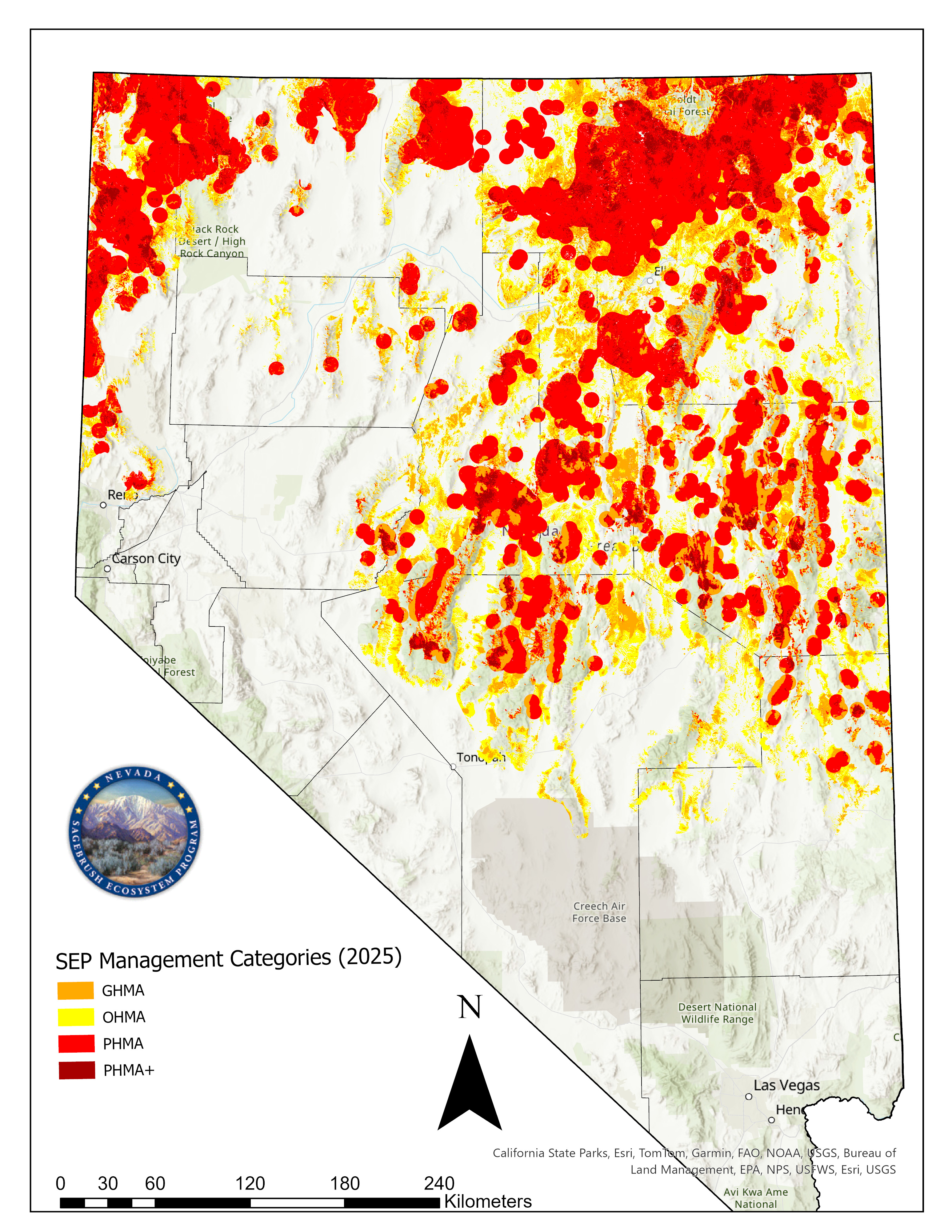
Habitat Management Areas for GRSG Map
2024 USGS Data Release